


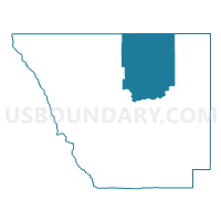
Larimer 403, Larimer County, Colorado
About
Outline

Summary
| Unique Area Identifier | 548811 |
| Name | Larimer 403 |
| County | Larimer County |
| State | Colorado |
| Area (square miles) | 340.73 |
| Land Area (square miles) | 339.72 |
| Water Area (square miles) | 1.01 |
| % of Land Area | 99.70 |
| % of Water Area | 0.30 |
| Latitude of the Internal Point | 40.85449610 |
| Longtitude of the Internal Point | -105.34588400 |
Maps

Graphs
Select a template below for downloading or customizing gragh for Larimer 403, Larimer County, Colorado


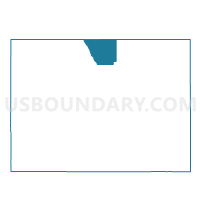
Neighbors
Neighoring Voting District (by Name) Neighboring Voting District on the Map
- ALBANY COUNTY FAIRGROUNDS Voting District, Albany County, WY
- Larimer 402, Larimer County, CO
- Larimer 404, Larimer County, CO
- Larimer 405, Larimer County, CO
- Larimer 406, Larimer County, CO
- Larimer 407, Larimer County, CO
- WILLADSEN ELEMENTARY SCHOOL Voting District, Laramie County, WY
Top 10 Neighboring County Subdivision (by Population) Neighboring County Subdivision on the Map
- Timnath-Wellington CCD, Larimer County, CO (18,311)
- Cheyenne West CCD, Laramie County, WY (7,254)
- Livermore CCD, Larimer County, CO (5,069)
- South Albany CCD, Albany County, WY (1,528)
Top 10 Neighboring Unified School District (by Population) Neighboring Unified School District on the Map
- Poudre School District R-1, CO (184,648)
- Laramie County School District 1, WY (86,198)
- Albany County School District 1, WY (36,299)
Top 10 Neighboring State Legislative District Lower Chamber (by Population) Neighboring State Legislative District Lower Chamber on the Map
- State House District 49, CO (83,740)
- State House District 12, WY (9,810)
- State House District 46, WY (9,230)
Top 10 Neighboring State Legislative District Upper Chamber (by Population) Neighboring State Legislative District Upper Chamber on the Map
- State Senate District 15, CO (155,929)
- State Senate District 8, WY (18,717)
- State Senate District 10, WY (18,279)
Top 10 Neighboring 111th Congressional District (by Population) Neighboring 111th Congressional District on the Map
Top 10 Neighboring Census Tract (by Population) Neighboring Census Tract on the Map
- Census Tract 19.02, Laramie County, WY (4,182)
- Census Tract 24.02, Larimer County, CO (2,963)
- Census Tract 25.03, Larimer County, CO (2,620)
- Census Tract 9639, Albany County, WY (2,141)
- Census Tract 24.01, Larimer County, CO (1,217)
Top 10 Neighboring 5-Digit ZIP Code Tabulation Area (by Population) Neighboring 5-Digit ZIP Code Tabulation Area on the Map
- 80524, CO (31,668)
- 82070, WY (19,766)
- 80549, CO (8,642)
- 80535, CO (2,636)
- 80512, CO (2,185)
- 80536, CO (1,759)
- 80545, CO (851)
- 82059, WY (135)
- 82084, WY (16)